Adirondack Nature Trails:
Bloomingdale Bog Trail

Bloomingdale Bog Trail Description
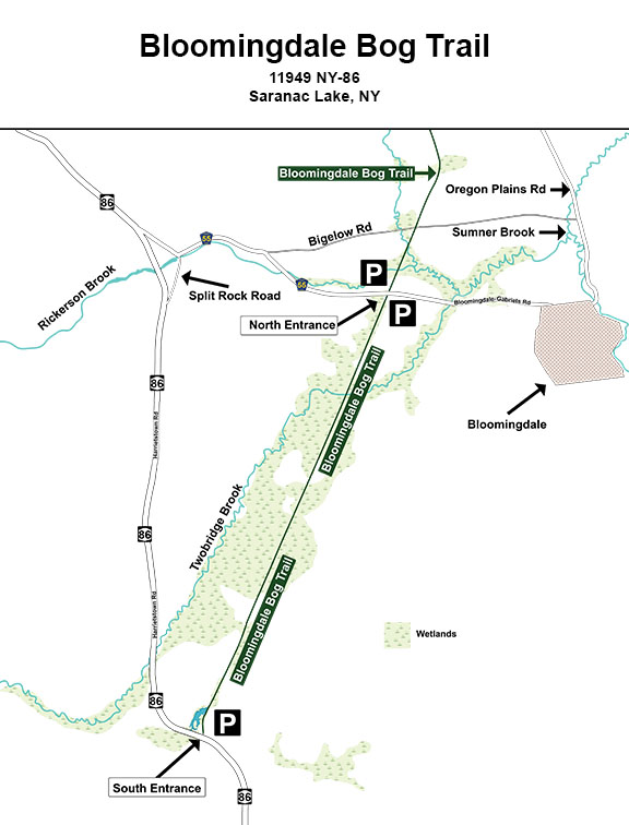
Getting There: Directions to the Bloomingdale Bog South Entrance

From downtown Lake Placid: Head north on Main Street, following the road as it makes a sharp left up the hill. Continue on NY-86 W/Saranac Avenue/Sara-Placid Road. Drive 8.4 miles. Turn LEFT onto River Street. Turn RIGHT onto Church Street. Turn LEFT onto Bloomingdale Avenue. Turn RIGHT onto Broadway Street. Continue onto NY-86 W/Lake Colby Drive. Drive 1.6 miles. The entrance to the Bloomingdale Bog southern trailhead will be on your RIGHT. The entry road is a narrow, rutted dirt road, leading to a very small unpaved parking lot. Parking is very limited at this trailhead.
From Saranac Lake: From the Town Hall, head north on Main Street toward Broadway Street. Make a slight LEFT onto Broadway Street. Continue onto NY-86 W/Lake Colby Drive. Drive for 1.6 miles. The entrance to the Bloomingdale Bog southern trailhead will be on your RIGHT. The entry road is a narrow, rutted dirt road, leading to a very small unpaved parking lot. Parking is very limited at this trailhead.
From Malone and points to the north: Take NY-30 South. Drive 31.7 miles. At Paul Smith's College, turn LEFT onto NY-86 East. Drive 9.2 miles. You will pass the intersection with the Lake Clear Road on your left and Connelly's Soft Ice Cream, also on your left. After driving another 1.8 miles, look for the south entrance to the Bloomingdale Bog Trail on your LEFT as you go up a hill. The entry road is a narrow, rutted dirt road, leading to a very small unpaved parking lot. Parking is very limited at this trailhead.
From Keene Valley and points southeast: From Keene Valley, head north on Route 73. Drive 19.1 miles. On the outskirts of Lake Placid, you will drive over a bridge across the Ausable River and past the ski jumps on your left and the Lake Placid Horse Show grounds on your right. Take a slight LEFT onto Old Military Road (County Highway 35). Drive 3.6 miles. You will come to an intersection; take a LEFT onto NY-86 West. Drive for 6.1 miles. Turn LEFT onto River Street. Turn RIGHT onto Church Street. Turn LEFT onto Bloomingdale Avenue. Turn RIGHT onto Broadway Street. Follow Broadway Street to NY-86 West. Drive 2.7 miles. The entrance to the Bloomingdale Bog southern trailhead will be on your RIGHT. The entry road is a narrow, rutted dirt road, leading to a very small unpaved parking lot. Parking is very limited at this trailhead.
View Larger Map to the South Entrance of the Bloomingdale Bog Trail
Getting There: Directions to the Bloomingdale Bog North Entrance

From downtown Lake Placid: Head north on Main Street, following the road as it makes a sharp left up the hill. Continue on NY-86 W/Saranac Avenue/Sara-Placid Road. Drive 5.5 miles. After you pass the Tractor Supply Company on your right, take a slight RIGHT onto the McKenzie Pond Road (County Route 33). Drive for 2.3 miles. Continue straight onto Pine Street. Turn RIGHT onto NY-3 East. Drive 6.1 miles. In the hamlet of Bloomingdale, continue straight onto State Street for 0.1 miles. Turn LEFT onto St. Regis Avenue. Continue onto the Bloomingdale-Gabriels Road. Drive 1.3 miles to the trailhead (where the Bloomingdale Bog Trail crosses the Bloomingdale-Gabriels Road). There are small pull-over areas for parking on either side of the road.
From Saranac Lake: From the Town Hall, head north on Main Street toward Broadway Street. Turn RIGHT to stay on Main Street. Turn LEFT onto Pine Street. Turn RIGHT onto NY-3 East. Drive 6.1 miles. In the hamlet of Bloomingdale, continue straight onto State Street for 0.1 miles. Turn LEFT onto St. Regis Avenue. Continue onto the Bloomingdale-Gabriels Road. Drive 1.3 miles to the trailhead (where the Bloomingdale Bog Trail crosses the Bloomingdale-Gabriels Road). There are small pull-over areas for parking on either side of the road.
From Malone and points to the north: Take NY-30 South. Drive 31.7 miles. At Paul Smith's College, turn LEFT onto NY-86 East. Drive 5.5 miles. Turn LEFT onto the Bloomingdale-Gabriels Road (County Highway 55). Drive 2.2 miles to the trailhead (where the Bloomingdale Bog Trail crosses the Bloomingdale-Gabriels Road). There are small pull-over areas for parking on either side of the road.
From Keene Valley and points southeast: From Keene Valley, head north on Route 73. Drive 17.5 miles. On the outskirts of Lake Placid, you will drive over a bridge across the Ausable River and past the ski jumps on your left and the Lake Placid Horse Show grounds on your right. Take a slight LEFT onto Old Military Road (County Highway 35), following the green sign directing you toward Saranac Lake. Drive 3.6 miles. You will come to an intersection; take a LEFT onto NY-86 West. Drive for 3.2 miles. After you pass the Tractor Supply Company on your right, take a slight RIGHT onto the McKenzie Pond Road (County Route 33). Drive for 2.3 miles. Continue straight onto Pine Street. Turn RIGHT onto NY-3 East. Drive 6.1 miles. In the hamlet of Bloomingdale, continue straight onto State Street for 0.1 miles. Turn LEFT onto St. Regis Avenue. Continue onto the Bloomingdale-Gabriels Road. Drive 1.3 miles to the trailhead (where the Bloomingdale Bog Trail crosses the Bloomingdale-Gabriels Road). There are small pull-over areas for parking on either side of the road.
